Tocht Mountainbike Val de Bagnes - Bike32921 - Photo

Optez pour le retour à la nature GUIDE+

© OpenStreetMap contributors
Lengte
Lengte
115 km
Max. hoogte
Max. hoogte
2797 m
Positief hoogteverschil
5188 m
Km-Effort
Km-Effort  
184 km
Min. hoogte
Min. hoogte
1206 m
Negatief hoogteverschil
5109 m
Boucle
Boucle
Neen
Datum van aanmaak :
2014-12-10 00:00:00.0
Laatste wijziging :
2014-12-10 00:00:00.0

(0 Bericht)

Mountainbike
Mountainbike
--
Moeilijkheid : Onbekend

Scan deze QR-code om de tocht te openen in de SityTrail-applicatie

Gratisgps-wandelapplicatie

Logo SityTrail SityTrail

IGN / Geografische instituten

SityTrail uit de App Store downloaden SityTrail uit Google Play downloaden

Logo SityTrail SityTrail World

De wereld gaat voor u open

SityTrail uit de App Store downloaden SityTrail uit Google Play downloaden SityTrail op Huawei AppGallery downloaden

Over ons

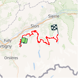
Tocht Mountainbike van 115 km beschikbaar op Valais/Wallis, Entremont, Val de Bagnes. Deze tocht wordt voorgesteld door My Switzerland.

Hoogteprofiel

POI's

POI Val de Bagnes - Verbier - Photo
My Switzerland
VAL DE BAGNES 
POI Anniviers - Grimentz - Photo
My Switzerland
ANNIVIERS 

Plaatsbepaling

Land:
Switzerland
Regio :
Valais/Wallis
Departement/Provincie :
Entremont
Gemeente :
Val de Bagnes
Locatie:
Unknown
Vertrek:(Dec)
Vertrek:(UTM)
363116 ; 5106240 (32T) N.

Wandeltochten in de omgeving

Tocht Te voet Val de Bagnes - Vollèges - Levron - Photo
Te voet
PRO

Te voet

Gemakkelijk
Val de Bagnes, Valais/Wallis, Entremont, Switzerland
3,3 km | 7,8 km-effort
1h 46min
Neen
Tocht Te voet Val de Bagnes - Vollèges - Levron - Photo
Te voet
PRO

Te voet

Gemakkelijk
Val de Bagnes, Valais/Wallis, Entremont, Switzerland
5,4 km | 10,3 km-effort
2h 20min
Neen
Tocht Te voet Val de Bagnes - Ancien Bisse du Levron - Photo
Te voet
PRO

Te voet

Gemakkelijk
Val de Bagnes, Valais/Wallis, Entremont, Switzerland
10,7 km | 13,4 km-effort
3h 2min
Neen
Tocht Stappen Val de Bagnes - Le Châble – Cabane de Louvie / Jour 2 - Photo
Stappen
Greg813

Stappen

Moeilijk
Val de Bagnes, Valais/Wallis, Entremont, Switzerland
12,4 km | 21 km-effort
3h 37min
Neen
Tocht Te voet Val de Bagnes - Promenade de la Dranse - Photo
Te voet
PRO

Te voet

Gemakkelijk
Val de Bagnes, Valais/Wallis, Entremont, Switzerland
7,1 km | 9,4 km-effort
2h 8min
Neen
Tocht Te voet Val de Bagnes - Bruson - Moay - Photo
Te voet
PRO

Te voet

Gemakkelijk
Val de Bagnes, Valais/Wallis, Entremont, Switzerland
3,6 km | 10 km-effort
2h 16min
Neen
Tocht Stappen Riddes - Croix de Coeur - Pierre Avoi - Photo
Stappen
jptritten

Stappen

Medium
(2)
Riddes, Valais/Wallis, Martigny, Switzerland
6,4 km | 10,9 km-effort
2h 26min
Ja
Tocht Te voet Isérables - Le Rosey - Taillay - Photo
Te voet
PRO

Te voet

Gemakkelijk
Isérables, Valais/Wallis, Martigny, Switzerland
4,4 km | 5,7 km-effort
1h 18min
Neen
Tocht Te voet Sembrancher - Chemins pédestre, commune de Sembrancher - Photo
Te voet
PRO

Te voet

Gemakkelijk
Sembrancher, Valais/Wallis, Entremont, Switzerland
4,9 km | 11,3 km-effort
2h 34min
Neen


Sluiten
Mijn abonnementen